The latest news of the flood and evacuation of 2,000 residents in Iwate Prefecture served as nature’s reminder. As residents in Japan grapple once again with the reality of the climate crisis, a new tool aims to enhance disaster preparedness by providing a comprehensive view of flood and landslide risks. YAMAP, a popular hiking and outdoor app, updated its 3D digital “Watershed Map” in June to include hazard maps for these dangers, offering a more intuitive way for users to assess potential risks, especially in areas prone to heavy rainfall.
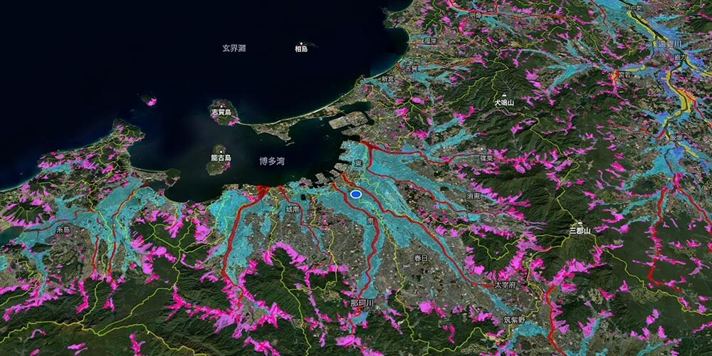
The updated map allows users to overlay flood and landslide hazard zones onto a digital representation of the landscape, making it possible to visualize how water flows and where risks are concentrated across entire watersheds, rather than just within specific administrative boundaries.
Developed with input from Professor Emeritus Yuji Kishi of Keio University, an advocate of watershed thinking (related to land use, water management, and conservation), the Watershed Map was initially released in May 2024. The map visually represents the interconnectedness of mountains, rivers, towns, and seas, providing a holistic view of the terrain. Since its release, it has attracted attention from a wide range of stakeholders, including media, educational institutions, local governments, private companies, and nonprofit organizations.
In recent years, Japan has seen a rise in the occurrence of “linear rainbands,” weather phenomena that can lead to sudden, intense downpours, overwhelming drainage systems and causing flash floods and landslides. Traditional hazard maps, which are often confined to municipal borders, can be insufficient for assessing the full scope of these risks. YAMAP’s Watershed Map addresses this by offering a broader perspective that transcends these limitations.
For individuals and families, the map provides a valuable resource when considering the safety of potential new homes or planning travel. By displaying risk information across multiple municipalities in a single, unified view, it simplifies the process of assessing land safety, making it easier to understand the potential dangers of specific locations during heavy rain events.
The digital map has educational potential too. YAMAP is encouraging its use in schools to enhance environmental and geographic education, helping students understand the complexities of natural water systems and the risks associated with them. Furthermore, the map is being promoted to government agencies and real estate professionals as a tool for improving land-use planning, flood control measures, and infrastructure resilience.
By providing a clear and comprehensive view of potential risks, the map empowers individuals, communities, and governments to make more informed decisions, ultimately strengthing the Japanese society’s disaster preparedness.
[Website] Watershed Map (Japanese)More on disaster preparedness in Japan
- 2026-01-09: TOPPAN Digital and OKI aim to scale Omuta flood alert system after pilot
- 2025-09-15: Fuji Kogyo's reusable Flood Guard F wins top disaster prevention award
- 2025-09-13: Re S upcycles airbag scraps into disaster readiness bags
- 2025-07-27: Instant Houses bridge everyday use with disaster preparedness
- 2025-07-06: Optimised Nutrition Food to boost disaster resilience for Hitoyoshi Japan